Our History
The Diocese of Kondoa was established in 2001, when it was divided from the Diocese of Central Tanganyika.
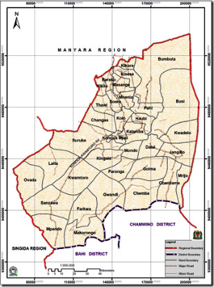
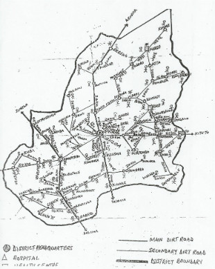 The Kondoa Diocese is in the Region of Dodoma and comprises the Kondoa and Chemba Districts; Chemba recently was made a district in its own right. Kondoa District is one of the five districts of the Dodoma Region of Tanzania. It is bordered to the south by Dodoma Rural District, and to the southeast by Kongwa District. The Diocese of Kondoa has 34 parishes, 8 deacons, 50 pastors and 97 katikisti. The area is predominantly Muslim with a population of about 600,000 people, of which approximately 67,000 are Christians and 10,000 Anglican.
The Diocese is linked with the Diocese of Rochester (UK) and benefits from ten parish to parish links and other support for Diocesan projects such as the Bible School and Women’s Empowerment Project. Each parish is also linked with a deanery in the Diocese of Central Tanganyika.
The Cathedral is currently the only parish in the diocese which is is self sustaining financially and all others are unable to contribute much by way of a parish share to support the Diocesan structure. Some churches meet in good buildings, some have no roofs, several have thatched roofs, two worship in school classrooms and two worship under trees. The Cathedral community is strong and has three services every Sunday.
Bishop Given is working to build ecumenical partnerships based on friendship in Christ and mutual respect with other local denominations such as the Roman Catholic and Lutheran churches. He is also building relationships with the Muslim community, which has shown its support, especially during the recent times with fundamentalist action against Christian leaders elsewhere in Tanzania.
 The majority tribe in Kondoa is the Warangi. The majority tribe in Chemba is the Waburunge. Other tribes in the diocese include the Wasandawe, Waasi, Wairaq, Masai, Bargaig, Wabemba and Wagogo.
The Kondoa District is very poor. The road system is almost non-existent, although one road, the main Cairo to Cape Town Road is gradually being tarmacked. The economy is mostly subsistence farming with only 25% of the land cultivated. Education attainment is the second lowest in the country. A major challenged faced by the people and local communities is crop failure caused by too much rain in the rainy season and too little rain in other months. Food prices have escalated dramatically in the last year and poverty has increased. However the people remain resilient and determined to own their land and their faith in God.
A local History of Kondoa in Kiswahili and English
Je, unafahamu haya kuhusu mji wa Kondoa? Historia ya mji wa Kondoa? Do you know this about Kondoa; about the history of the town of Kondoa?
Mji wa Kondoa ni mji wa kihistoria katika ukanda huu wa Kati. Ni makao makuu ya Wilaya ya Kondoa. The town of Kondoa is a historical town in the central zone. It is the main base of the district of Kondoa
Ulianza zamani kama kituo cha kupumzikia watumwa waliokuwa wakipelekwa pwani. (The town) started long ago as a place of rest for slaves who were being taken to the coast
Njia moja ya utumwa ilipitia hapa na kumbukumbu yake ni mtaa unaoitwa Ubembeni. One road of slavery passed here and it's memorial is the area which is called Ubembeni
Asili ya kuitwa hivyo ni kutokana na kukaliwa na kabila la Wabemba toka Kongo Zaire pale biashara ya utumwa ilipopigwa marufuku mwaka 1900. The origins of this name comes from it being stayed in by the Wabemba who come from the Congo/Zaire back when the business of slavery was made illegal in 1900
Asili ya neno Kondoa linatokana na mto unaopita karibu na mji, ambao Warangi waliuita M?koondo wa Iraangi. Pia mji wa Kondoa hujulikana kama ULA. The origins of the word Kondoa comes from the river which passes through it, which the Warangi call 'Mukoondo wa Iraangi'. Also the town of Kondoa is known as 'Ula'
Hapa palikuwa na soko la zamani, na biashara iliyofanyika hapo ni ile ya kuuziana na kununuliana vitu. Eneo hilo ni pale ambapo soko la zamani lilikuwepo. Mahali hapo kwa Kirangi paliitwa “WULA” ikiwa na maana “NUNUA”. Here there was a market long ago, and business which was done there is that of to buy and sell to one another things. That place is where the ancient market place was. That place (Ula, by the main Dodoma-Arusha road on the opposite side than the way into Kondoa town), in kirangi, was called 'wula' which has the meaning 'buy'.
Mitaa ya mji wa Kondoa ina majina ya matukio au watu maarufu wa wakati ule kama ifuatavyo: The areas of the town of Kondoa have the names of famous events or people of the time, as follows:
-
Ubembeni – Walikaa kabila la Wabemba toka Congo (Zaire) mara baada ya biashara ya utumwa kufungwa. Mabaki ya kabila hilo bado wapo hadi sasa. Where the Wabemba stayed when slavery was made illegal. Those who stayed are still there today. •Chemchemi – Mtaa huu unatokana na chemchemi isiyokauka ambayo hutoa maji ya moto nyakati za asubuhi. This area is so-called due to the spring which never dries out which gives hot water every morning.
-
Iboni – Alikuwa mtu maarufu sana na mtawala wa eneo hilo. Aliheshimika kwa hekima na busara zake. He was a very famous person and leader of this area. He was respected for his wisdom.
-
Kwapakacha – Ni jina la mtawala aliyeitwa Pakacha ambaye alikuwa mwanangwa wa eneo hili. Is the name of a leader who was called Pakacha who was born in this area
-
Bomani – Linatokana na neno Boma. Lilikuwa jengo la watawala wa Kijerumani kwa kuendeshea shughuli zote za utawala. Kwa sasa jengo hilo ni ofisi ya Mkuu wa Wilaya. Comes from the word 'boma'. It was a a building of the colonial rulers of Germany, built for the running of their governmental business. Now this building is used by the District Council leader
-
Miningani- Mtaa huu upo karibu na Uwanja wa ndege ambapo kuna miti ya mininga. This area is near the airfield where there are lots of 'mininga' trees
-
Maji ya Shamba- Ni sehemu yenye Bwawa linalotumiwa kwa kilimo na kumwagilia mbogamboga. Is an area with a lake which is used for farming and the watering of various produce (Maji ya Shamba lit means 'water of farm')
-
Mnarani – Mtaa huu ndipo mahali palipojengwa mnara wa kumbukumbu ya uhuru wa Tanganyika mwaka 1961. This area is where it was built the statue of memorial of freedom of Tanganyika in the year 1961
[Kutoka gazeti la Kirangi la Ngwy??ra -Toleo Maalumu kuhusu Kondoa, Kwiinyambala, Mei 2011 ] ....ITAENDELEA. (copyright)